Introduction
What is GEFS
GEFS is the Geographic Enterprise Foundational Service and provides the official reference for the geographical information and capabilities at the corporate level for their usage across the overall WFP.
Geographical Master Data is a valuable business asset for the Organization.
Maintaining high-quality, well-defined, and standardized sets of geographical names, aliases and shapes has been, during the years, one of the most critical issues of the digital strategy.
Adopt the standards
After years of corporate systems development at WFP, we had to recognize that each of them evolved in their "own way" in dealing with the location information without one clear and common interoperability framework for the same ground, knowledge, and expertise to approaching the geospatial data domain
Every developer must adopt the standards
GEFS should envisage a set of standards:
- Proper compliance with the API Guidelines
- A well-architected developer framework for the consumption and resolution of names
- A proper compliance with the UN geospatial standards (UNGN, OGC, etc)
- Easiness to use for the different use cases
Geographical information structure
From a high-level point of view, GEFS defines a data structure that can be depicted with the following macro-categories:
- Administrative Areas, Units
- Cities
- Points of Interest
These categories can be further broken down, in a more granular way, into a hierarchy with the following list of administrative levels:
- Countries
- Regions
- Provinces
- Municipalities
- Settlements
- Cities
- Points of Interest
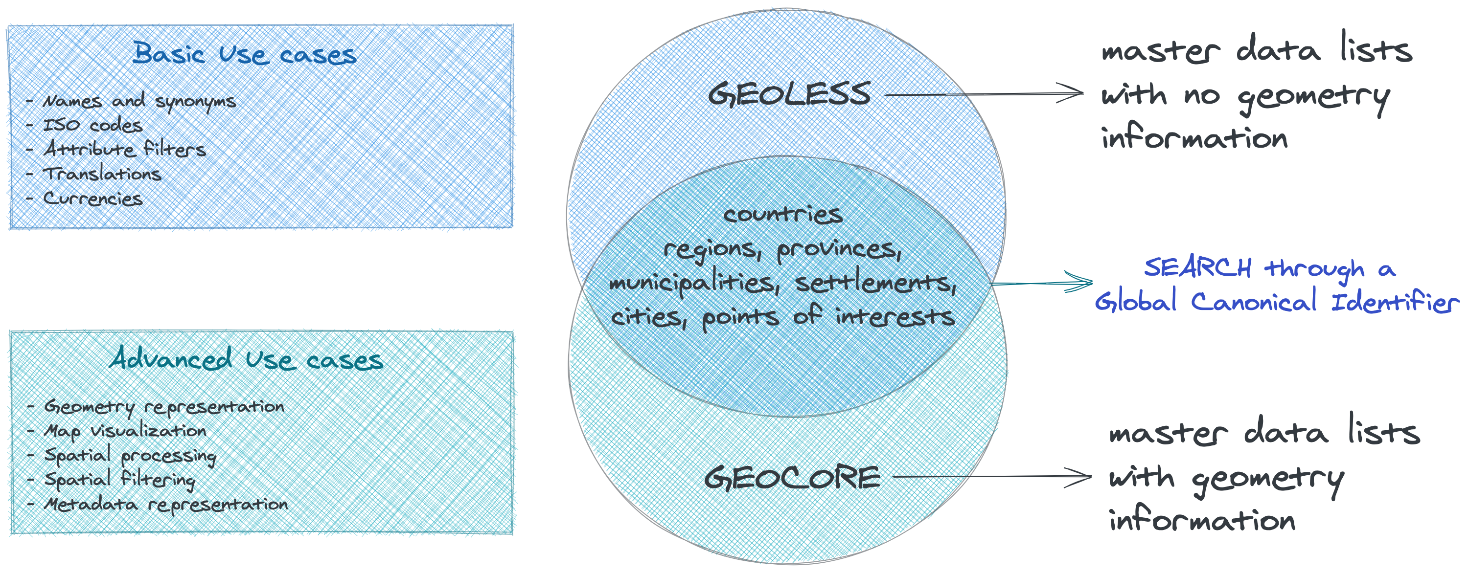
The GEFS project aims to standardize and represent those above layers in a meaningful way in order to describe the whole base reference for locations data at the global level in two different realms:
- GEOLESS: a realm of Geographical Master data where the spatial representation is not taken into account.
- GEOCORE: a realm of Geographical Master data where the spatial representation matters.
In other words, GEOLESS and GEOCORE are basically two sides of the same coin, so their use depends on whether the user has to consume the geographical component of the data source or not. The adoption of GEFS can start gradually from the basic use case like for example filling a dropdown list and evolve into more complex use cases where the developer needs to implement advanced functionalities such as web mapping or spatial processing. Both the realms share the same search capabilities and use the same reference key that allows to uniquely identifies each record among the hierarchy. The two realms can be represented with the following logical model:
At the core of GEFS there is a set of capabilities providing results for the basic and the advanced use cases:
-
Getting the list of items of a given collection from the master data (i.e.: Countries, Regions, etc) and filtering the result by properties eventually
-
Getting a result with hypermedia links to describe the parental relationships in the hierarchy and the connected resource between the realms
-
Performing searches that match with given query patterns (i.e.: partial name of a country, etc)
-
Referring to URIs with a resource-centric model for the alignment of target databases
Data maintenance and lifecycle
TBD

Changelog
- 1 September 2021 - First version